One might not immediately consider the changes that the creation of a new bridge would have on the cityscape, but major changes did happen
between 1824 and 1831 when the New London Bridge was built 100 feet (about 30 meters) west (upstream) of the original bridge. Access to the old bridge was
via Fish Street but the new bridge required a new approach which resulted in the complete alteration of the area between the then Miles's Lane (St. Michals
Lane until the mid 1700s) on the west and Fish Street Hill on the east, and the area from Great Eastcheap on the north to the River Thames on the south.
Over 150 buildings, including St. Michael's Church, along with various lanes, courts, and yards, were sacrificed to make way for the approach to the
new bridge. More than one establishment known to have issued tokens was taken down in this effort.
Perhaps the greatest singular event to change the face of London was the Blitz during World War II. Starting in the afternoon of 07 September 1940,
nightly raids carried out by hundreds of German fighters and bombers pounded the city night and day for 57 days. The Blitz continued until 11 May
1941 when Germany shifted its forces against the Soviet Union. Though the Blitz had ended, bombing raids continued on London, including over 2500
V-1 and V-2 rockets hitting the city. During the course of the war, almost two million buildings were damaged or destroyed. Despite the
devastation, many areas were rebuilt on top of the old plan of the city. But many were not.
A more slower-moving process that has changed the city is simply that of "progress." Streets have been changed to accommodate traffic patterns.
Massive buildings stretch not only into the sky but across the ground at their bases, eating up the old alleys and courts. Bounded by Tower
Street on the north and Thames Street on the south, the area from Water Lane east to The Tower once had over 100 houses and shops as well as
numerous lanes, courts, and alleys. The area was entirely leveled by bombs during the War but, even with the devastation, the outline of Beer Lane
was still very obvious in 1947 air photos, along with lines of foundations, some still matching the old surveys from the 18th century. Now?
Now, the entire area is covered by a massive low-rise known as Tower Place, although the entrance to the parking portion does somewhat
coincide with the outlet of the former Beer Lane on the south. Like the area cleared for the new approach to London Bridge, more than one
token-issuing place occupied this area.
Likewise, numerous passages and alleys do still continue to exist in other parts of the city, accommodated by gaps and tunnels between modern
buildings.
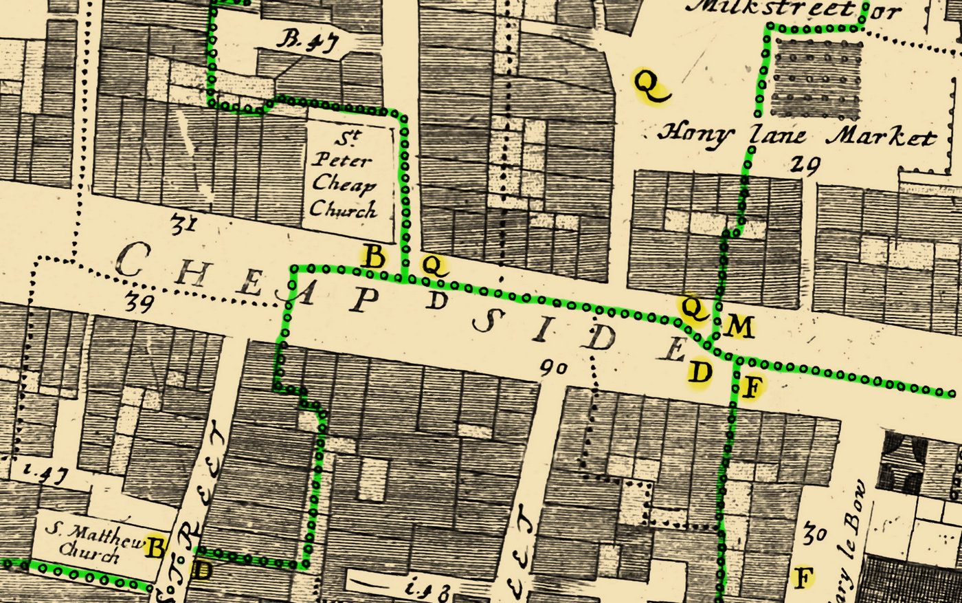
The basis for the place names identified on this site is the classification by George C Williamson in his 1889 work, Trade Tokens Issued in
the Seventeenth Century in England, Wales, and Ireland, by Corporations, Merchants, Tradesmen, etc.. Williamson's work was, itself, a new
and revised version of William Boyne's earlier compendium from 1858. Williamson has 410 places in his classification, each of which has
tokens having a more distinct location. Other works have added to these 410 places and every effort has been made here to capture the actual
geographic location represented by those place names.
The Ogilby and Morgan map of 1677 titled "A Large and Accurate Map of the City of London, Ichnographically Describing all the Streets, Lanes,
Alleys, Courts, Yards, Churches, Halls, and Houses, &c. Actually Surveyed and Delineated, By John Ogilby, Esq; His Majesties Cosmographer"
has many of these places located, some by name, some merely delineated but not identified. Being from 1677, and compiled in the years prior,
this map is contemporary with the tokens issued in the 17th century, the bulk of which were from 1648 to 1672, and, therefore, serves as the
main source used to create the map of places.
Many places lay outside the City of London and also fell beyond the boundaries of the Ogilby Map. Places in Westminster and parts of the
East End (Wapping, East Smithfield, Blackwall, etc) are not contained within Ogilby's map so other sources were consulted and some of these were
also georeferenced. John Rocque's A Plan of the cities of London and Westminster, and Borough of Southwark; with the Contiguous Buildings, etc
from 1746 covers these areas as well as Southwark. A bit later in time, Robert Horwood's Plan of the Cities of London and Westminster the Borough of
Southwark, and Parts adjoining Shewing Every House finished in 1799 covers much the same area and both were valuable resources in locating additional
places. Some areas were so unchanged that, upon confirmation of the staticness of their location using Rocque and Horwood, they were digitized directly
from present-day maps.
See also Wards and Token-Issuing Places.
Streets, Lanes, Courts, Alleys, etc of London in the 17th Century
While the layout of some parts of London today is eerily similar to what it was in the middle of the 17th century, in many other areas
it is completely unrecognizable. The Great Fire of 1666 took place during the period when the Trade Tokens of the 17th Century were issued
but most areas were rebuilt following the pre-fire plan. Other more relatively recent events have altered the layout of the city with much
greater impact. Industrialization, for example, caused a number of railway stations and tracks to be built. Of these, one with an enormous
impact on the layout was the construction of the Shoreditch Station in 1840. This was later renamed Bishopgate in 1846 and ultimately was replaced
by the Liverpool Street Station in 1874. The Liverpool Street Station utterly changed the face of most of the ward of Bishopgate Without.
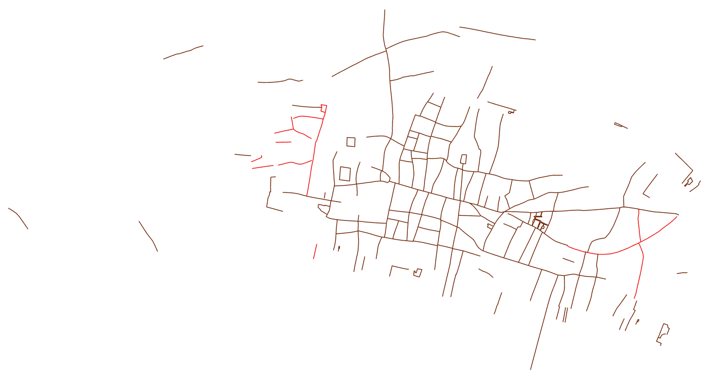 The first step was to move the Ogilby map from paper to the digital world and to give it geographical context. The scans of the 24 pages were
georeferenced (See Adding the 17th and 18th Century Maps) so that it would overlay a modern map of the city. Each of the
streets, courts, lanes, etc were identified and digitized to create a shapefile. In many places, the lines overlay present-day streets perfectly.
In other areas, they run through lobbies of buildings, through parks, or into St. Katherine's docks where one would never guess that an alley had once
lain. This was a laborious process since any subsequent corrections to the alignment of the Ogilby map made as a result of finding an obscure
landmark that had survived for 350 years required a reanalysis of streets in the area and a correction of their coordinates.
The first step was to move the Ogilby map from paper to the digital world and to give it geographical context. The scans of the 24 pages were
georeferenced (See Adding the 17th and 18th Century Maps) so that it would overlay a modern map of the city. Each of the
streets, courts, lanes, etc were identified and digitized to create a shapefile. In many places, the lines overlay present-day streets perfectly.
In other areas, they run through lobbies of buildings, through parks, or into St. Katherine's docks where one would never guess that an alley had once
lain. This was a laborious process since any subsequent corrections to the alignment of the Ogilby map made as a result of finding an obscure
landmark that had survived for 350 years required a reanalysis of streets in the area and a correction of their coordinates.